
This Sounded Like Boring Zoning; Until Someone Asked the Right Question
Quincy’s airport overlay debate quickly turned into a real conversation about what you can build and where
Most city code conversations do not grab people by the collar. This one should. On paper, the “Airport Overlay Zone Code Update” sounds like exactly the kind of dry land-use item most people would expect to skim past. But the moment a local property owner stood up and started asking what this would mean for commercially zoned land near the Quincy airport, the conversation got real in a hurry.
This was no longer just about maps, acronyms, and development regulations. It became a question a lot of people in Quincy can understand immediately: if the city changes the rules around the airport, what can still be built there, how hard will it be to build, and who gets affected next?
The answer matters because this conversation touches future development, private property, airport protection, and how much control Quincy keeps over its own growth instead of leaving those decisions to broader state standards.
TL:DR
Quincy is moving to adopt an Airport Overlay Zone because state law requires cities to have development rules that discourage incompatible uses near general aviation airports.
City staff argued this is the more flexible local option compared to simply defaulting to broader WSDOT standards.
The biggest practical question raised at council was what this means for privately owned land near the airport, especially commercial property.
The overlay does not replace existing zoning, but it adds another layer of review and restrictions depending on where a property sits within the airport compatibility zones.
The discussion made it clear this is not just abstract planning language. It is about what people may or may not be able to do with land near one of Quincy’s important community assets.
Why This Conversation Matters More Than It Sounds Like It Should
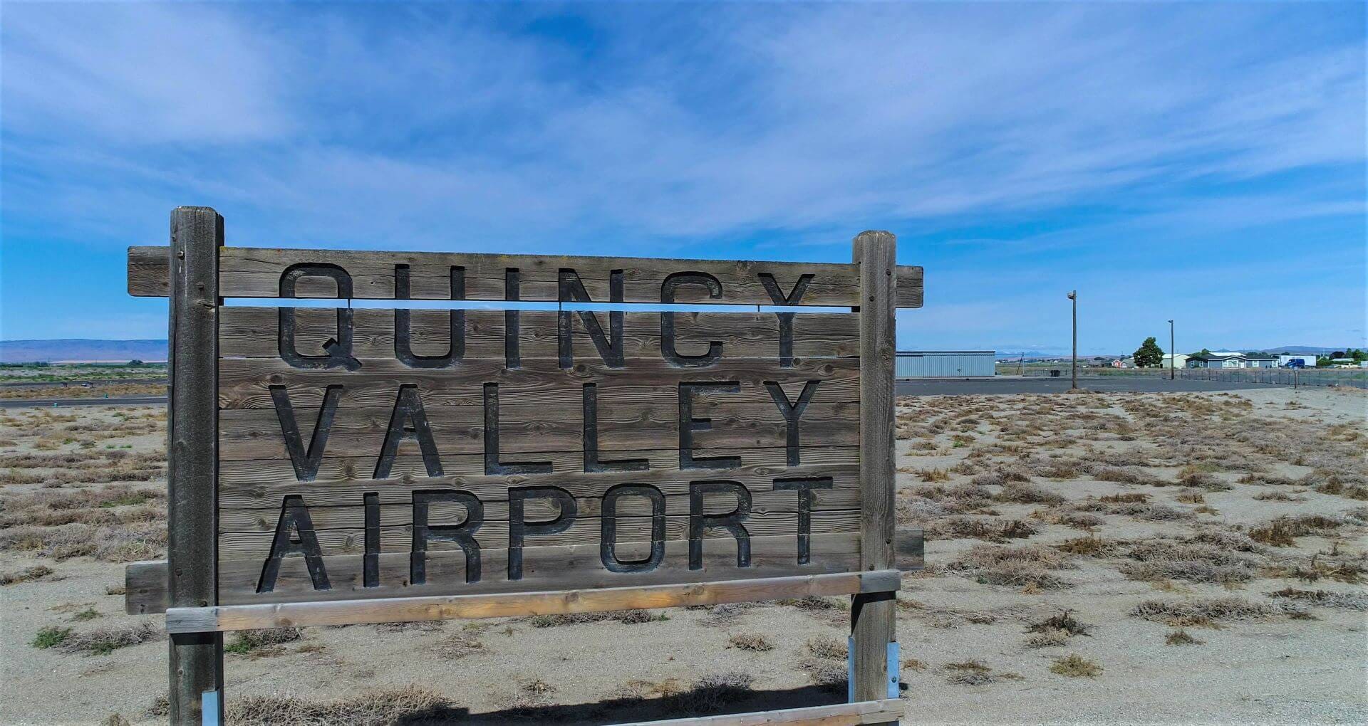
At first glance, this looked like one more technical public hearing. The council packet described it as a code amendment to establish an Airport Overlay Zone, or AOZ, around the Quincy Municipal Airport. The stated purpose was straightforward enough: discourage incompatible land uses near the airport, protect flight paths with height limits, and bring Quincy into compliance with state law.
That may sound like routine housekeeping. It is not.
“Quincy currently has no airport zoning.”
What made this hearing worth paying attention to is that the city was not simply debating whether airport-area rules should exist. Staff’s position was that the state already requires them.
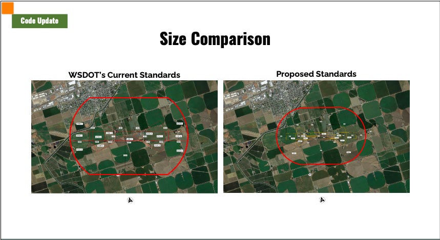
The real issue in front of council was whether Quincy would create a local overlay that fits Quincy better, or continue operating without one and leave future projects near the airport more exposed to broader Washington State Department of Transportation aviation standards that staff said were more restrictive.
That is an important distinction. This was not a choice between regulation and no regulation. It was a choice about who gets to shape the rules and how blunt or how tailored those rules will be.
Quincy Is Trying to Set Its Own Rules Instead of Falling Under Broader State Limits
The city’s staff report laid out the basic problem clearly. Quincy currently has no airport zoning on the books, and because of that, any development near the airport would be subject to the underlying zoning plus WSDOT aviation standards. According to the city, a previous project review near the airport helped show that those default standards were overly restrictive for Quincy’s situation. That is what pushed the city toward writing its own local airport overlay code.
One of the presentation slides said it plainly: the proposed code update would “allow for greater flexibility than WSDOT standards.” That line may have been the single most important argument staff made all night.
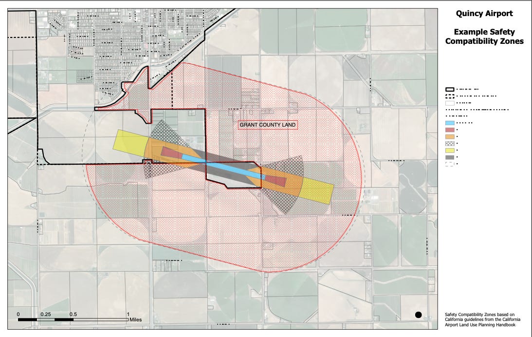
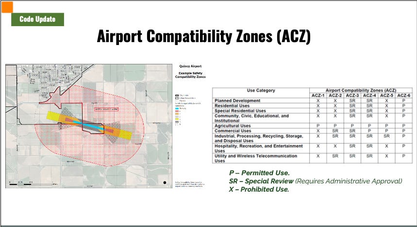
The overlay would create six Airport Compatibility Zones around the airport. Depending on which zone a property falls into, certain uses would be permitted, some would require special review, and others would be prohibited. The code also adds height restrictions tied to airport safety geometry, not just a simple flat height cap. In other words, the base zoning does not disappear, but airport-related restrictions get layered on top of it.
That may not sound dramatic on paper, but on the ground it can affect whether a project moves easily, faces additional review, or is not allowed at all.
The Real Tension Was About Land Use, Not Airport Support
The most important moment in the hearing came when local property owner Kurt Morris stepped up with the kind of questions regular people would ask if they had land near the airport or were thinking about buying, selling, or developing there.
He wanted to know whether this overlay would actually change the zoning on his property or simply add another layer to what is already there. He asked what it would mean for commercial property, whether something like a four-story hotel could still be built, and whether special review would now become part of the process. He also wanted a clearer answer on the underlying issue: is this really making development easier than it would be otherwise, or is it just adding a new obstacle that property owners did not realize was coming?
That exchange was where the whole issue stopped sounding like planning jargon and started sounding like Quincy.
“Allows for greater flexibility than WSDOT standards.”
Because that is what people actually care about. Not whether an item is labeled G-1 in the council packet. They care whether a business opportunity still works, whether a piece of land keeps its value, whether a project they have in mind becomes harder, and whether the city is protecting something important without quietly making development more complicated than it needs to be.
One of the key clarifications from staff was that this overlay does not rezone the land. The underlying zoning still applies. But the airport overlay can still trigger additional review or restrictions depending on the exact location and proposed use.
That may sound like a small distinction, but it is not. It means the answer to “Can I build this?” is no longer just found in the base zoning map. It also depends on whether the property sits in one of these airport compatibility zones and how the proposal interacts with airport safety and height rules.
This Is a Technical Code Update With Very Practical Consequences
The city’s proposed code is built around a three-part system. In the compatibility chart, a use may be marked as permitted, special review, or prohibited. If it is permitted in the airport overlay chart and permitted in the underlying zone, it can move forward. If it is labeled special review, it must go through an administrative review focused specifically on airport compatibility. And if it is prohibited in that airport zone, it is out regardless of what the base zoning would otherwise allow.
The chart itself tells the story. Residential and community-type uses are the most restricted closer to the runway. Commercial uses are prohibited in the closest zone, require special review in some of the next zones, and become permitted farther out. Agricultural uses are allowed throughout all six zones. Industrial and utility-type uses get more flexibility the farther they are from the airport core.
That is why the conversation around hotel height, commercial use, and future development near the airport mattered so much. The overlay is not just symbolic. It changes the way future proposals get evaluated.
It also became clear during the hearing that the height rules are not especially intuitive. One councilmember asked for a more straightforward explanation of the height requirements in each zone, but staff explained that the limits are not based on one simple number per zone. Instead, they are based on a larger FAA-style set of “imaginary surfaces” around the airport, including approach, transitional, horizontal, and conical surfaces.
That complexity is probably one of the biggest takeaways from the hearing. Even if the city is right that this is the better local option, the rules are still not easy for an ordinary resident or property owner to understand just by glancing at a map.
This Was Also About Local Control and Future Growth
Another important point that surfaced during the discussion was jurisdiction. The proposed overlay applies within city limits. Outside city limits, land remains under Grant County’s review unless it is later annexed into the city. The city, Port of Quincy, and Grant County met before this hearing and concluded that each jurisdiction would continue reviewing permits in its own area.
“What does this actually mean for my property?”
That may sound like a small procedural detail, but it has implications. Councilmembers openly noted that land in the Urban Growth Area could potentially benefit from annexation if the city’s airport overlay is indeed more flexible than the county’s WSDOT-based standards. That means this code conversation is not only about current city property. It is also connected to how Quincy may grow outward and what standards could shape that future growth.
This is the kind of thing that tends to matter long before most people realize it does. By the time a project is proposed, the framework has already been set.
A Small But Telling Detail: Other Utilities Were Paying Attention Too
Buried in the staff report was another detail worth noticing. Grant County PUD recommended language clarifying that the new overlay should not restrict or impair the operation, maintenance, repair, replacement, upgrade, or easement rights for existing utility facilities that were lawfully established before adoption of the code. The city accepted that recommendation and added it into the proposed chapter.
That matters because it shows this was not just an airport issue. Other infrastructure players saw the potential consequences too and wanted their protections written into the code before it moved forward.
What This Means to You
If you do not own land near the airport, it may be tempting to tune out this kind of conversation. That would be a mistake.
If you care about Quincy’s ability to control its own growth, this matters.
If you care about whether important local infrastructure like the airport is protected without needlessly strangling future development, this matters.
If you own land, hope to buy land, run a business, invest in property, or just want to understand how decisions made in council chambers shape what Quincy looks like five or ten years from now, this matters.
And if you have ever wondered why some projects seem simple while others get bogged down in layers of review, this conversation gives you a pretty clear answer: because the rules underneath the project often matter as much as the project itself.
The airport overlay discussion may have started as dry code language, but by the end of the hearing it was clearly about something much bigger. It was about whether Quincy can protect one of its important long-term assets while still leaving room for sensible growth, private investment, and clear local decision-making.
That balance is not glamorous, but it is one of the most important jobs local government has. And when the questions start sounding like, “What does this mean for my land?” or “Can I still build here?” that is when the rest of us should start paying closer attention too, because those are the moments when policy stops being abstract and starts shaping the future of the community we live in.